

Key Insights
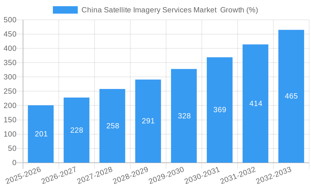
The China satellite imagery services market is experiencing robust growth, driven by increasing government investments in infrastructure development, heightened demand for precise geospatial data across various sectors, and advancements in satellite technology. The market's Compound Annual Growth Rate (CAGR) of 13.20% from 2019 to 2024 indicates a significant upward trajectory. This growth is fueled by the expanding applications of satellite imagery in sectors such as geospatial data acquisition and mapping for urban planning and infrastructure projects, natural resource management for efficient land utilization and environmental monitoring, surveillance and security for public safety and border control, and conservation and research efforts for biodiversity studies and environmental impact assessments. Furthermore, the increasing adoption of satellite imagery in disaster management for rapid damage assessment and effective response mechanisms contributes to market expansion. Key players are strategically focusing on enhancing data processing capabilities and developing advanced analytics to cater to the rising demand for actionable insights derived from satellite imagery. The government sector is a major contributor to market revenue, followed by construction, transportation and logistics, and the military and defense sectors.
Looking ahead to 2033, the continued expansion of the Chinese economy and its growing technological prowess will further propel market growth. The increasing availability of high-resolution satellite imagery at competitive prices, coupled with the development of user-friendly data analysis tools, will broaden market accessibility. While challenges such as data security concerns and regulatory hurdles might exist, the overall market outlook remains positive, with significant opportunities for market participants to capitalize on the burgeoning demand for advanced geospatial intelligence and data-driven decision-making. The market’s considerable size, coupled with the government’s emphasis on technological innovation, positions China as a key player in the global satellite imagery services landscape.
China Satellite Imagery Services Market: A Comprehensive Report (2019-2033)
This comprehensive report provides an in-depth analysis of the China Satellite Imagery Services Market, offering invaluable insights for industry stakeholders, investors, and strategic decision-makers. Covering the period from 2019 to 2033, with a focus on 2025, this report unveils the market's dynamics, trends, and future potential. The market is projected to reach xx Million by 2033, exhibiting a robust CAGR of xx% during the forecast period (2025-2033).
China Satellite Imagery Services Market Market Dynamics & Concentration
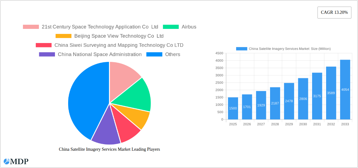
The China Satellite Imagery Services Market is characterized by a moderate level of concentration, with several key players vying for market share. While the market is fragmented to some extent, larger companies like Airbus and China National Space Administration hold significant influence. The market’s growth is driven by technological advancements in satellite technology, increasing demand for high-resolution imagery across various sectors, and supportive government policies promoting the development of the space industry.
- Market Concentration: The top 5 players hold an estimated xx% market share in 2025, with the remaining share distributed among numerous smaller companies.
- Innovation Drivers: Advancements in sensor technology, improved image processing algorithms, and the development of cloud-based platforms are fueling innovation.
- Regulatory Frameworks: Government regulations concerning data security and access to satellite imagery play a significant role in shaping market dynamics. These regulations are both supportive and restrictive, impacting market growth depending on specific implementations.
- Product Substitutes: While satellite imagery offers unique advantages, alternative data sources like aerial photography and LiDAR compete to some extent, especially in specific applications.
- End-User Trends: Demand is growing across various sectors, with government agencies, military and defense, and construction taking the lead in adoption, increasing usage and driving revenue growth. The need for data in sustainable resource management and disaster response continues to increase the demand for this service.
- M&A Activities: The number of mergers and acquisitions in the sector has been moderate in recent years, with xx deals recorded between 2019 and 2024. This trend is expected to increase with consolidation anticipated in the coming years.
China Satellite Imagery Services Market Industry Trends & Analysis
The China Satellite Imagery Services Market is experiencing significant growth, driven by several key factors. Technological advancements in satellite technology are constantly improving image resolution, accuracy, and availability. The increasing demand for high-resolution imagery across various sectors, particularly in government, construction, and defense, further fuels market expansion. Furthermore, supportive government policies and initiatives promoting the space industry are creating a favorable environment for market growth. The market is witnessing a shift towards cloud-based platforms for data storage and processing, increasing accessibility and efficiency. Competitive dynamics are shaped by technological innovation, pricing strategies, and the ability to offer comprehensive solutions. The market penetration of satellite imagery services is growing rapidly, particularly in applications requiring detailed geographical data.
Leading Markets & Segments in China Satellite Imagery Services Market
The government sector is the dominant end-user, accounting for an estimated xx% of the market in 2025. This is fueled by extensive use of imagery for urban planning, environmental monitoring, and national security purposes. Geospatial data acquisition and mapping is the largest application segment, followed by surveillance and security. The fastest-growing segment is expected to be disaster management, driven by the increasing frequency and severity of natural disasters.
Key Drivers by Segment:
- Government: Government initiatives promoting infrastructure development, urban planning, and environmental monitoring are key drivers.
- Construction: Demand for accurate mapping and site surveying for construction projects.
- Transportation and Logistics: Use of satellite imagery for route planning, traffic monitoring, and infrastructure management.
- Military and Defense: High-resolution imagery for intelligence gathering, surveillance, and target acquisition.
- Forestry and Agriculture: Monitoring crop health, deforestation, and resource management.
- Geospatial Data Acquisition and Mapping: Growing demand for detailed geographical information.
- Surveillance and Security: Government and private sector use for security and monitoring purposes.
- Disaster Management: Rapid response and assessment post-disaster events.
Dominance analysis indicates that Eastern China holds the largest regional market share due to high infrastructure development and government investment in this region.
China Satellite Imagery Services Market Product Developments
Recent product developments have focused on higher-resolution imagery, improved data processing capabilities, and the integration of artificial intelligence (AI) and machine learning (ML) for enhanced analysis and interpretation. The market is witnessing the emergence of cloud-based platforms and value-added services, improving accessibility and offering tailored solutions for specific applications. This innovation drives market competitiveness and ensures the market remains responsive to the evolving needs of various sectors.
Key Drivers of China Satellite Imagery Services Market Growth
Several factors contribute to the market's growth. Technological advancements in satellite sensors and data processing capabilities improve image quality and analysis. Government initiatives promoting space technology and data utilization create a supportive environment. Increasing demand across diverse sectors, from construction and agriculture to defense and environmental management, further fuels market expansion. The availability of high-resolution imagery is key, driving adoption and increasing market size.
Challenges in the China Satellite Imagery Services Market Market
The market faces challenges such as data security concerns, stringent government regulations on data access and usage, and the potential for supply chain disruptions related to satellite technology components. Competition from established and emerging players can lead to price pressures. The high initial investment required for satellite technology and data infrastructure can be a barrier to entry for new companies.
Emerging Opportunities in China Satellite Imagery Services Market
Long-term growth is fueled by several factors. Advancements in AI and ML offer opportunities to automate data processing and analysis, improving efficiency. Strategic partnerships between satellite imagery providers and data analytics firms are expected to create new value-added services. Expanding into emerging markets with increasing demand for satellite imagery further fuels long-term growth potential. The development of new applications, such as precision agriculture and environmental monitoring, creates additional market opportunities.
Leading Players in the China Satellite Imagery Services Market Sector
- 21st Century Space Technology Application Co Ltd
- Airbus
- Beijing Space View Technology Co Ltd
- China Siwei Surveying and Mapping Technology Co LTD
- China National Space Administration
- Mapbox
- Beijing Zero Map Information Technology Co Ltd
- CHANG GUANG SATELLITE TECHNOLOGY CO LTD
- National Satellite Meteorological Center
- HEAD Aerospace Group
Key Milestones in China Satellite Imagery Services Market Industry
- June 2023: China shared 1.5 TB of satellite imagery data (400 scenes) with BRICS nations, fostering collaboration and boosting market opportunities for Chinese vendors.
- January 2023: Spacety, a Chinese Space Science and Technology Research Institute, provided synthetic aperture radar satellite images to a Russian firm, highlighting the market's involvement in global events and the military applications of Chinese satellite imagery services.
Strategic Outlook for China Satellite Imagery Services Market Market
The China Satellite Imagery Services Market is poised for significant growth, driven by technological innovation, increasing demand across various sectors, and supportive government policies. Strategic partnerships, expansion into new markets, and the development of innovative applications will be crucial for success. The market's future potential is substantial, with continued growth expected over the forecast period.
China Satellite Imagery Services Market Segmentation
-
1. Application
- 1.1. Geospatial Data Acquisition and Mapping
- 1.2. Natural Resource Management
- 1.3. Surveillance and Security
- 1.4. Conservation and Research
- 1.5. Disaster Management
- 1.6. Intelligence
-
2. End-User
- 2.1. Government
- 2.2. Construction
- 2.3. Transportation and Logistics
- 2.4. Military and Defense
- 2.5. Forestry and Agriculture
- 2.6. Other End-Users
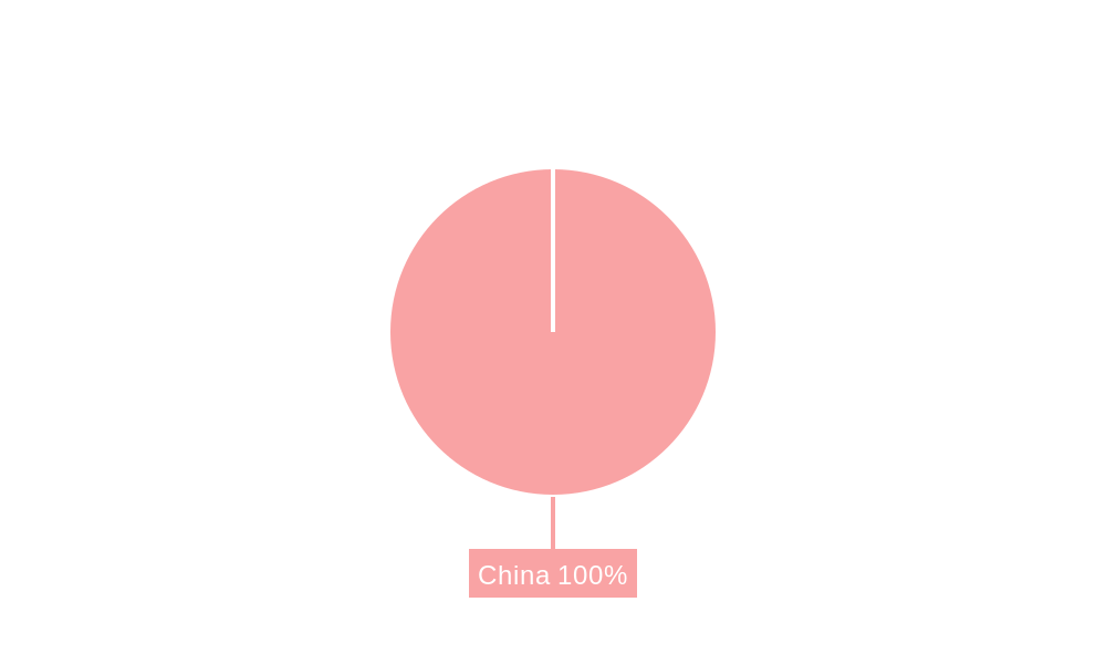
China Satellite Imagery Services Market Segmentation By Geography
- 1. China
China Satellite Imagery Services Market REPORT HIGHLIGHTS
| Aspects | Details |
|---|---|
| Study Period | 2019-2033 |
| Base Year | 2024 |
| Estimated Year | 2025 |
| Forecast Period | 2025-2033 |
| Historical Period | 2019-2024 |
| Growth Rate | CAGR of 13.20% from 2019-2033 |
| Segmentation |
|
Table of Contents
- 1. Introduction
- 1.1. Research Scope
- 1.2. Market Segmentation
- 1.3. Research Methodology
- 1.4. Definitions and Assumptions
- 2. Executive Summary
- 2.1. Introduction
- 3. Market Dynamics
- 3.1. Introduction
- 3.2. Market Drivers
- 3.2.1. The country's Investments in Space Technology and Defence; Adoption of Big Data and Imagery Analytics
- 3.3. Market Restrains
- 3.3.1. High Cost of Satellite Imaging Data Acquisition and Processing; High-resolution Images Offered by Other Imaging Technologies
- 3.4. Market Trends
- 3.4.1. The country's Investments in Space Technology and Defense Drives Market Growth.
- 4. Market Factor Analysis
- 4.1. Porters Five Forces
- 4.2. Supply/Value Chain
- 4.3. PESTEL analysis
- 4.4. Market Entropy
- 4.5. Patent/Trademark Analysis
- 5. China Satellite Imagery Services Market Analysis, Insights and Forecast, 2019-2031
- 5.1. Market Analysis, Insights and Forecast - by Application
- 5.1.1. Geospatial Data Acquisition and Mapping
- 5.1.2. Natural Resource Management
- 5.1.3. Surveillance and Security
- 5.1.4. Conservation and Research
- 5.1.5. Disaster Management
- 5.1.6. Intelligence
- 5.2. Market Analysis, Insights and Forecast - by End-User
- 5.2.1. Government
- 5.2.2. Construction
- 5.2.3. Transportation and Logistics
- 5.2.4. Military and Defense
- 5.2.5. Forestry and Agriculture
- 5.2.6. Other End-Users
- 5.3. Market Analysis, Insights and Forecast - by Region
- 5.3.1. China
- 5.1. Market Analysis, Insights and Forecast - by Application
- 6. Competitive Analysis
- 6.1. Market Share Analysis 2024
- 6.2. Company Profiles
- 6.2.1 21st Century Space Technology Application Co Ltd
- 6.2.1.1. Overview
- 6.2.1.2. Products
- 6.2.1.3. SWOT Analysis
- 6.2.1.4. Recent Developments
- 6.2.1.5. Financials (Based on Availability)
- 6.2.2 Airbus
- 6.2.2.1. Overview
- 6.2.2.2. Products
- 6.2.2.3. SWOT Analysis
- 6.2.2.4. Recent Developments
- 6.2.2.5. Financials (Based on Availability)
- 6.2.3 Beijing Space View Technology Co Ltd
- 6.2.3.1. Overview
- 6.2.3.2. Products
- 6.2.3.3. SWOT Analysis
- 6.2.3.4. Recent Developments
- 6.2.3.5. Financials (Based on Availability)
- 6.2.4 China Siwei Surveying and Mapping Technology Co LTD
- 6.2.4.1. Overview
- 6.2.4.2. Products
- 6.2.4.3. SWOT Analysis
- 6.2.4.4. Recent Developments
- 6.2.4.5. Financials (Based on Availability)
- 6.2.5 China National Space Administration
- 6.2.5.1. Overview
- 6.2.5.2. Products
- 6.2.5.3. SWOT Analysis
- 6.2.5.4. Recent Developments
- 6.2.5.5. Financials (Based on Availability)
- 6.2.6 Mapbox
- 6.2.6.1. Overview
- 6.2.6.2. Products
- 6.2.6.3. SWOT Analysis
- 6.2.6.4. Recent Developments
- 6.2.6.5. Financials (Based on Availability)
- 6.2.7 Beijing Zero Map Information Technology Co Ltd
- 6.2.7.1. Overview
- 6.2.7.2. Products
- 6.2.7.3. SWOT Analysis
- 6.2.7.4. Recent Developments
- 6.2.7.5. Financials (Based on Availability)
- 6.2.8 CHANG GUANG SATELLITE TECHNOLOGY CO LTD
- 6.2.8.1. Overview
- 6.2.8.2. Products
- 6.2.8.3. SWOT Analysis
- 6.2.8.4. Recent Developments
- 6.2.8.5. Financials (Based on Availability)
- 6.2.9 National Satellite Meteorological Center
- 6.2.9.1. Overview
- 6.2.9.2. Products
- 6.2.9.3. SWOT Analysis
- 6.2.9.4. Recent Developments
- 6.2.9.5. Financials (Based on Availability)
- 6.2.10 HEAD Aerospace Group
- 6.2.10.1. Overview
- 6.2.10.2. Products
- 6.2.10.3. SWOT Analysis
- 6.2.10.4. Recent Developments
- 6.2.10.5. Financials (Based on Availability)
- 6.2.1 21st Century Space Technology Application Co Ltd
List of Figures
- Figure 1: China Satellite Imagery Services Market Revenue Breakdown (Million, %) by Product 2024 & 2032
- Figure 2: China Satellite Imagery Services Market Share (%) by Company 2024
List of Tables
- Table 1: China Satellite Imagery Services Market Revenue Million Forecast, by Region 2019 & 2032
- Table 2: China Satellite Imagery Services Market Revenue Million Forecast, by Application 2019 & 2032
- Table 3: China Satellite Imagery Services Market Revenue Million Forecast, by End-User 2019 & 2032
- Table 4: China Satellite Imagery Services Market Revenue Million Forecast, by Region 2019 & 2032
- Table 5: China Satellite Imagery Services Market Revenue Million Forecast, by Country 2019 & 2032
- Table 6: China Satellite Imagery Services Market Revenue Million Forecast, by Application 2019 & 2032
- Table 7: China Satellite Imagery Services Market Revenue Million Forecast, by End-User 2019 & 2032
- Table 8: China Satellite Imagery Services Market Revenue Million Forecast, by Country 2019 & 2032
Frequently Asked Questions
1. What is the projected Compound Annual Growth Rate (CAGR) of the China Satellite Imagery Services Market ?
The projected CAGR is approximately 13.20%.
2. Which companies are prominent players in the China Satellite Imagery Services Market ?
Key companies in the market include 21st Century Space Technology Application Co Ltd, Airbus, Beijing Space View Technology Co Ltd, China Siwei Surveying and Mapping Technology Co LTD, China National Space Administration, Mapbox, Beijing Zero Map Information Technology Co Ltd, CHANG GUANG SATELLITE TECHNOLOGY CO LTD, National Satellite Meteorological Center, HEAD Aerospace Group.
3. What are the main segments of the China Satellite Imagery Services Market ?
The market segments include Application, End-User.
4. Can you provide details about the market size?
The market size is estimated to be USD XX Million as of 2022.
5. What are some drivers contributing to market growth?
The country's Investments in Space Technology and Defence; Adoption of Big Data and Imagery Analytics.
6. What are the notable trends driving market growth?
The country's Investments in Space Technology and Defense Drives Market Growth..
7. Are there any restraints impacting market growth?
High Cost of Satellite Imaging Data Acquisition and Processing; High-resolution Images Offered by Other Imaging Technologies.
8. Can you provide examples of recent developments in the market?
June 2023: The country awarded a contract to share satellite Imagery data with BRICS countries after the signing of an agreement on Cooperation on the BRICS Remote Sensing Satellite Constellation and shared 400 scenes of satellite imagery data with the BRICS countries, with the total volume amounting to 1.5 TB, which supports the growth of satellite imagery services market in China by creating a business opportunity for the Chinese vendors.
9. What pricing options are available for accessing the report?
Pricing options include single-user, multi-user, and enterprise licenses priced at USD 3800, USD 4500, and USD 5800 respectively.
10. Is the market size provided in terms of value or volume?
The market size is provided in terms of value, measured in Million.
11. Are there any specific market keywords associated with the report?
Yes, the market keyword associated with the report is "China Satellite Imagery Services Market ," which aids in identifying and referencing the specific market segment covered.
12. How do I determine which pricing option suits my needs best?
The pricing options vary based on user requirements and access needs. Individual users may opt for single-user licenses, while businesses requiring broader access may choose multi-user or enterprise licenses for cost-effective access to the report.
13. Are there any additional resources or data provided in the China Satellite Imagery Services Market report?
While the report offers comprehensive insights, it's advisable to review the specific contents or supplementary materials provided to ascertain if additional resources or data are available.
14. How can I stay updated on further developments or reports in the China Satellite Imagery Services Market ?
To stay informed about further developments, trends, and reports in the China Satellite Imagery Services Market , consider subscribing to industry newsletters, following relevant companies and organizations, or regularly checking reputable industry news sources and publications.
Methodology
Step 1 - Identification of Relevant Samples Size from Population Database


Step 2 - Approaches for Defining Global Market Size (Value, Volume* & Price*)

Note*: In applicable scenarios
Step 3 - Data Sources
Primary Research
- Web Analytics
- Survey Reports
- Research Institute
- Latest Research Reports
- Opinion Leaders
Secondary Research
- Annual Reports
- White Paper
- Latest Press Release
- Industry Association
- Paid Database
- Investor Presentations

Step 4 - Data Triangulation
Involves using different sources of information in order to increase the validity of a study
These sources are likely to be stakeholders in a program - participants, other researchers, program staff, other community members, and so on.
Then we put all data in single framework & apply various statistical tools to find out the dynamic on the market.
During the analysis stage, feedback from the stakeholder groups would be compared to determine areas of agreement as well as areas of divergence
