

Key Insights
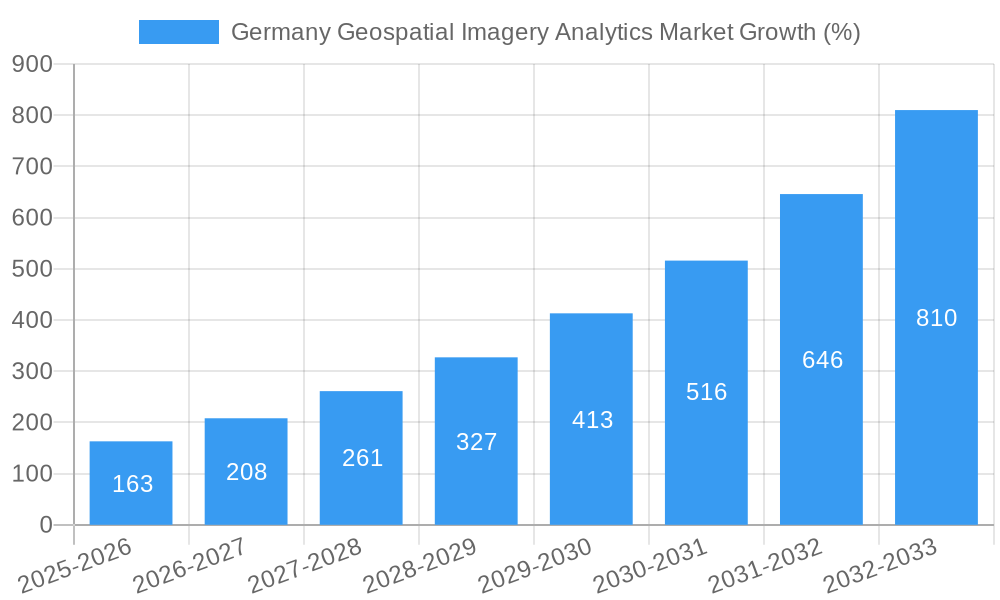
The Germany Geospatial Imagery Analytics market is experiencing robust growth, projected to reach €0.62 billion in 2025 and exhibiting a Compound Annual Growth Rate (CAGR) of 26.77% from 2025 to 2033. This expansion is driven by several key factors. Increasing government investments in infrastructure development and smart city initiatives fuel demand for precise geospatial data analysis. Furthermore, the rising adoption of advanced technologies such as AI and machine learning for improved image processing and data interpretation is significantly accelerating market growth. Precision agriculture, environmental monitoring, and urban planning are sectors benefiting immensely from these advancements. The presence of major players like Hexagon AB, Esri, Airbus, and TomTom, alongside emerging companies like Planet Labs and Maxar Technologies, contributes to a competitive yet innovative landscape. These companies are continuously developing and improving their offerings, leading to more efficient and cost-effective solutions for diverse applications. While data privacy concerns and the high cost of advanced analytics solutions pose some challenges, the overall market trajectory remains positive, fueled by continuous technological improvements and expanding application areas.
The forecast period of 2025-2033 suggests a substantial increase in market value. Estimating the market size for future years using the provided CAGR, the market is anticipated to experience significant expansion, driven by the increasing adoption of geospatial analytics across various industries within Germany. This growth is further facilitated by advancements in data acquisition technologies, sophisticated analytical tools, and a burgeoning demand for location-based insights. The competitive landscape, characterized by both established industry giants and innovative startups, fosters a dynamic market, further accelerating innovation and market penetration. Although challenges remain, such as regulatory hurdles and data security, the overall market outlook for Germany's geospatial imagery analytics sector remains exceptionally promising.
Germany Geospatial Imagery Analytics Market: A Comprehensive Report (2019-2033)
This comprehensive report provides an in-depth analysis of the Germany Geospatial Imagery Analytics Market, offering invaluable insights for businesses, investors, and stakeholders seeking to navigate this dynamic sector. The report covers the period from 2019 to 2033, with a base year of 2025 and a forecast period extending to 2033. We analyze market dynamics, trends, leading players, and future opportunities, providing actionable intelligence to drive strategic decision-making. The market is projected to reach xx Million by 2033, exhibiting a CAGR of xx% during the forecast period.
Germany Geospatial Imagery Analytics Market Market Dynamics & Concentration
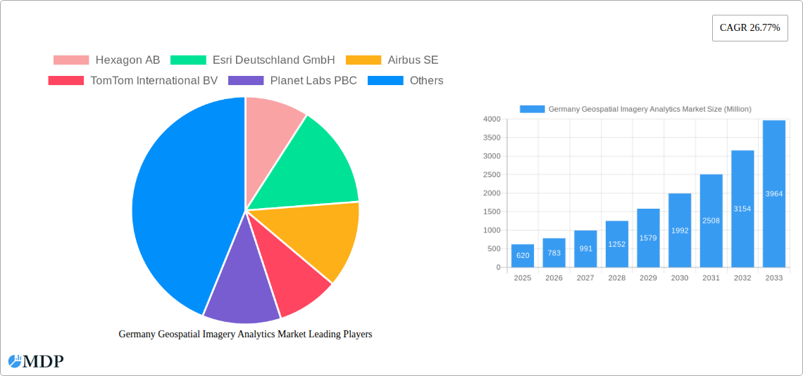
The German geospatial imagery analytics market is experiencing robust growth, driven by increasing demand across diverse sectors. Market concentration is moderate, with a few dominant players and several niche players vying for market share. Hexagon AB, Esri Deutschland GmbH, and Airbus SE currently hold a significant portion of the market, while other players like TomTom International BV, Planet Labs PBC, and Oracle Corporation are actively expanding their presence.
Market Concentration Metrics (2024 Estimates):
- Top 3 players: xx% market share
- Top 5 players: xx% market share
Innovation Drivers:
- Advancements in AI and Machine Learning for data analysis.
- Development of high-resolution satellite imagery and sensor technologies.
- Growing adoption of cloud-based geospatial platforms.
Regulatory Frameworks:
- German and EU data privacy regulations (GDPR) significantly influence data handling practices.
- Increasing government investments in geospatial infrastructure are supporting market growth.
Product Substitutes & End-User Trends:
- Traditional surveying methods are being gradually replaced by geospatial imagery analytics.
- End-users across sectors (agriculture, construction, utilities) are increasingly leveraging data-driven insights.
M&A Activities:
- The number of M&A deals in the German geospatial imagery analytics market has increased steadily over the past five years, reflecting the high growth potential and strategic importance of the sector. A total of xx M&A deals were recorded between 2019 and 2024.
Germany Geospatial Imagery Analytics Market Industry Trends & Analysis
The German geospatial imagery analytics market is characterized by significant growth, driven by a confluence of factors. Technological advancements, particularly in AI and high-resolution imagery, are fueling innovation. Increasing demand from various sectors like agriculture, urban planning, and environmental monitoring contributes significantly to market expansion. The market's growth is further propelled by rising government investment in digital infrastructure and increasing adoption of cloud-based solutions.
Market Growth Drivers:
- Technological Advancements: Improved sensor technology and AI algorithms are enabling more accurate and detailed analysis of geospatial data.
- Increased Data Availability: The growing accessibility of high-resolution satellite and drone imagery provides a wealth of data for analysis.
- Rising Demand Across Sectors: Various industries, including agriculture, construction, and transportation, are utilizing geospatial analytics for improved efficiency and decision-making.
- Government Initiatives: Government support for digitalization and infrastructure development further promotes market growth.
Competitive Dynamics: The market is moderately competitive, with major players focusing on product innovation, strategic partnerships, and expanding their service offerings. Smaller, specialized companies are also playing a significant role, catering to niche market segments.
Leading Markets & Segments in Germany Geospatial Imagery Analytics Market
The German Geospatial Imagery Analytics market shows strong growth across several segments. The most significant market segments include:
- Agriculture: Precision farming applications using geospatial data are driving substantial growth in this segment.
- Urban Planning & Development: Geospatial analytics is crucial for urban planning, enabling efficient resource management and infrastructure development.
- Environmental Monitoring: Monitoring deforestation, pollution, and climate change is facilitated by geospatial data analysis.
Key Drivers of Segment Dominance:
- Agriculture: Government subsidies for precision agriculture and increasing awareness of sustainable farming practices.
- Urban Planning: Growing urbanization and need for efficient resource allocation in rapidly developing cities.
- Environmental Monitoring: Increasing environmental concerns and the need for accurate data for conservation efforts.
The strongest regional growth is observed in urbanized areas of Germany, where the demand for advanced analytics is higher. This is driven by a combination of factors including robust infrastructure, high technological adoption rates, and a well-established digital economy.
Germany Geospatial Imagery Analytics Market Product Developments
Recent advancements in geospatial imagery analytics focus on AI-powered solutions for automated data processing and improved accuracy. Cloud-based platforms are also gaining popularity due to their scalability and accessibility. New products are emphasizing integration with existing GIS systems and improved user interfaces. The market is seeing the emergence of specialized solutions targeting specific industry needs, such as precision agriculture and environmental monitoring.
Key Drivers of Germany Geospatial Imagery Analytics Market Growth
The German geospatial imagery analytics market is experiencing substantial growth due to several key factors: increased government investment in digital infrastructure, the rising adoption of cloud-based solutions, and the development of sophisticated AI-powered analytics tools. The growing demand for data-driven insights across diverse sectors further fuels market expansion. Strong regulatory support for data utilization and environmental monitoring also positively impacts market growth.
Challenges in the Germany Geospatial Imagery Analytics Market Market
Despite significant growth potential, the German market faces challenges, including the high cost of data acquisition and processing, data privacy regulations impacting data accessibility, and the need for skilled professionals capable of interpreting complex geospatial data. Competition from established players also presents a challenge for new entrants to the market. These factors limit market penetration to some extent.
Emerging Opportunities in Germany Geospatial Imagery Analytics Market
Long-term growth in the German geospatial imagery analytics market is anticipated due to continuous technological innovation and strategic partnerships between technology providers and industry stakeholders. The increasing availability of high-resolution satellite imagery and the development of advanced analytics tools will unlock new applications and further expand market potential. Focus on developing user-friendly platforms and solutions will increase market accessibility.
Leading Players in the Germany Geospatial Imagery Analytics Market Sector
- Hexagon AB
- Esri Deutschland GmbH
- Airbus SE
- TomTom International BV
- Planet Labs PBC
- Oracle Corporation
- BAE Systems
- Maxar Technologies
- Microsoft Corporation
- Google LLC
- *List Not Exhaustive
Key Milestones in Germany Geospatial Imagery Analytics Market Industry
- September 2023: European Space Imaging (EUSI) partnered with Umbra, expanding SAR data availability in Germany. This significantly increased the data supply for analytics applications.
- January 2024: LiveEO launched EUDR Expert, an AI-powered compliance solution addressing the EU Deforestation Regulation (EUDR). This development highlights the growing importance of regulatory compliance in the sector and creates new market opportunities for AI-driven solutions.
Strategic Outlook for Germany Geospatial Imagery Analytics Market Market
The future of the German geospatial imagery analytics market appears bright, driven by ongoing technological advancements, increasing demand from diverse sectors, and supportive government policies. Strategic partnerships, investments in R&D, and a focus on developing user-friendly, scalable solutions will be crucial for success in this rapidly evolving market. The market's long-term growth trajectory is projected to be robust, offering substantial opportunities for players who can adapt to the changing landscape and leverage emerging technologies.
Germany Geospatial Imagery Analytics Market Segmentation
-
1. Type
- 1.1. Imagery Analytics
- 1.2. Video Analytics
-
2. Deployment Mode
- 2.1. On-premise
- 2.2. Cloud
-
3. Organization Size
- 3.1. SMEs
- 3.2. Large Enterprises
-
4. Verticals
- 4.1. Insurance
- 4.2. Agriculture
- 4.3. Defense and Security
- 4.4. Environmental Monitoring
- 4.5. Engineering and Construction
- 4.6. Government
- 4.7. Other Verticals
Germany Geospatial Imagery Analytics Market Segmentation By Geography
- 1. Germany
Germany Geospatial Imagery Analytics Market REPORT HIGHLIGHTS
| Aspects | Details |
|---|---|
| Study Period | 2019-2033 |
| Base Year | 2024 |
| Estimated Year | 2025 |
| Forecast Period | 2025-2033 |
| Historical Period | 2019-2024 |
| Growth Rate | CAGR of 26.77% from 2019-2033 |
| Segmentation |
|
Table of Contents
- 1. Introduction
- 1.1. Research Scope
- 1.2. Market Segmentation
- 1.3. Research Methodology
- 1.4. Definitions and Assumptions
- 2. Executive Summary
- 2.1. Introduction
- 3. Market Dynamics
- 3.1. Introduction
- 3.2. Market Drivers
- 3.2.1 The Growth of Infrastructure Development and Urban Planning in the Country; The Growing Demand for High-resolution Satellite Data for Crisis Response
- 3.2.2 Environmental Monitoring
- 3.2.3 and Nature Conservation Efforts
- 3.3. Market Restrains
- 3.3.1 The Growth of Infrastructure Development and Urban Planning in the Country; The Growing Demand for High-resolution Satellite Data for Crisis Response
- 3.3.2 Environmental Monitoring
- 3.3.3 and Nature Conservation Efforts
- 3.4. Market Trends
- 3.4.1. Imagery Analytics Contributes Significantly to the Market Share
- 4. Market Factor Analysis
- 4.1. Porters Five Forces
- 4.2. Supply/Value Chain
- 4.3. PESTEL analysis
- 4.4. Market Entropy
- 4.5. Patent/Trademark Analysis
- 5. Germany Geospatial Imagery Analytics Market Analysis, Insights and Forecast, 2019-2031
- 5.1. Market Analysis, Insights and Forecast - by Type
- 5.1.1. Imagery Analytics
- 5.1.2. Video Analytics
- 5.2. Market Analysis, Insights and Forecast - by Deployment Mode
- 5.2.1. On-premise
- 5.2.2. Cloud
- 5.3. Market Analysis, Insights and Forecast - by Organization Size
- 5.3.1. SMEs
- 5.3.2. Large Enterprises
- 5.4. Market Analysis, Insights and Forecast - by Verticals
- 5.4.1. Insurance
- 5.4.2. Agriculture
- 5.4.3. Defense and Security
- 5.4.4. Environmental Monitoring
- 5.4.5. Engineering and Construction
- 5.4.6. Government
- 5.4.7. Other Verticals
- 5.5. Market Analysis, Insights and Forecast - by Region
- 5.5.1. Germany
- 5.1. Market Analysis, Insights and Forecast - by Type
- 6. Competitive Analysis
- 6.1. Market Share Analysis 2024
- 6.2. Company Profiles
- 6.2.1 Hexagon AB
- 6.2.1.1. Overview
- 6.2.1.2. Products
- 6.2.1.3. SWOT Analysis
- 6.2.1.4. Recent Developments
- 6.2.1.5. Financials (Based on Availability)
- 6.2.2 Esri Deutschland GmbH
- 6.2.2.1. Overview
- 6.2.2.2. Products
- 6.2.2.3. SWOT Analysis
- 6.2.2.4. Recent Developments
- 6.2.2.5. Financials (Based on Availability)
- 6.2.3 Airbus SE
- 6.2.3.1. Overview
- 6.2.3.2. Products
- 6.2.3.3. SWOT Analysis
- 6.2.3.4. Recent Developments
- 6.2.3.5. Financials (Based on Availability)
- 6.2.4 TomTom International BV
- 6.2.4.1. Overview
- 6.2.4.2. Products
- 6.2.4.3. SWOT Analysis
- 6.2.4.4. Recent Developments
- 6.2.4.5. Financials (Based on Availability)
- 6.2.5 Planet Labs PBC
- 6.2.5.1. Overview
- 6.2.5.2. Products
- 6.2.5.3. SWOT Analysis
- 6.2.5.4. Recent Developments
- 6.2.5.5. Financials (Based on Availability)
- 6.2.6 Oracle Corporation
- 6.2.6.1. Overview
- 6.2.6.2. Products
- 6.2.6.3. SWOT Analysis
- 6.2.6.4. Recent Developments
- 6.2.6.5. Financials (Based on Availability)
- 6.2.7 BAE Systems
- 6.2.7.1. Overview
- 6.2.7.2. Products
- 6.2.7.3. SWOT Analysis
- 6.2.7.4. Recent Developments
- 6.2.7.5. Financials (Based on Availability)
- 6.2.8 Maxar Technologies
- 6.2.8.1. Overview
- 6.2.8.2. Products
- 6.2.8.3. SWOT Analysis
- 6.2.8.4. Recent Developments
- 6.2.8.5. Financials (Based on Availability)
- 6.2.9 Microsoft Corporation
- 6.2.9.1. Overview
- 6.2.9.2. Products
- 6.2.9.3. SWOT Analysis
- 6.2.9.4. Recent Developments
- 6.2.9.5. Financials (Based on Availability)
- 6.2.10 Google LLC*List Not Exhaustive
- 6.2.10.1. Overview
- 6.2.10.2. Products
- 6.2.10.3. SWOT Analysis
- 6.2.10.4. Recent Developments
- 6.2.10.5. Financials (Based on Availability)
- 6.2.1 Hexagon AB
List of Figures
- Figure 1: Germany Geospatial Imagery Analytics Market Revenue Breakdown (Million, %) by Product 2024 & 2032
- Figure 2: Germany Geospatial Imagery Analytics Market Share (%) by Company 2024
List of Tables
- Table 1: Germany Geospatial Imagery Analytics Market Revenue Million Forecast, by Region 2019 & 2032
- Table 2: Germany Geospatial Imagery Analytics Market Volume Billion Forecast, by Region 2019 & 2032
- Table 3: Germany Geospatial Imagery Analytics Market Revenue Million Forecast, by Type 2019 & 2032
- Table 4: Germany Geospatial Imagery Analytics Market Volume Billion Forecast, by Type 2019 & 2032
- Table 5: Germany Geospatial Imagery Analytics Market Revenue Million Forecast, by Deployment Mode 2019 & 2032
- Table 6: Germany Geospatial Imagery Analytics Market Volume Billion Forecast, by Deployment Mode 2019 & 2032
- Table 7: Germany Geospatial Imagery Analytics Market Revenue Million Forecast, by Organization Size 2019 & 2032
- Table 8: Germany Geospatial Imagery Analytics Market Volume Billion Forecast, by Organization Size 2019 & 2032
- Table 9: Germany Geospatial Imagery Analytics Market Revenue Million Forecast, by Verticals 2019 & 2032
- Table 10: Germany Geospatial Imagery Analytics Market Volume Billion Forecast, by Verticals 2019 & 2032
- Table 11: Germany Geospatial Imagery Analytics Market Revenue Million Forecast, by Region 2019 & 2032
- Table 12: Germany Geospatial Imagery Analytics Market Volume Billion Forecast, by Region 2019 & 2032
- Table 13: Germany Geospatial Imagery Analytics Market Revenue Million Forecast, by Type 2019 & 2032
- Table 14: Germany Geospatial Imagery Analytics Market Volume Billion Forecast, by Type 2019 & 2032
- Table 15: Germany Geospatial Imagery Analytics Market Revenue Million Forecast, by Deployment Mode 2019 & 2032
- Table 16: Germany Geospatial Imagery Analytics Market Volume Billion Forecast, by Deployment Mode 2019 & 2032
- Table 17: Germany Geospatial Imagery Analytics Market Revenue Million Forecast, by Organization Size 2019 & 2032
- Table 18: Germany Geospatial Imagery Analytics Market Volume Billion Forecast, by Organization Size 2019 & 2032
- Table 19: Germany Geospatial Imagery Analytics Market Revenue Million Forecast, by Verticals 2019 & 2032
- Table 20: Germany Geospatial Imagery Analytics Market Volume Billion Forecast, by Verticals 2019 & 2032
- Table 21: Germany Geospatial Imagery Analytics Market Revenue Million Forecast, by Country 2019 & 2032
- Table 22: Germany Geospatial Imagery Analytics Market Volume Billion Forecast, by Country 2019 & 2032
Frequently Asked Questions
1. What is the projected Compound Annual Growth Rate (CAGR) of the Germany Geospatial Imagery Analytics Market?
The projected CAGR is approximately 26.77%.
2. Which companies are prominent players in the Germany Geospatial Imagery Analytics Market?
Key companies in the market include Hexagon AB, Esri Deutschland GmbH, Airbus SE, TomTom International BV, Planet Labs PBC, Oracle Corporation, BAE Systems, Maxar Technologies, Microsoft Corporation, Google LLC*List Not Exhaustive.
3. What are the main segments of the Germany Geospatial Imagery Analytics Market?
The market segments include Type, Deployment Mode, Organization Size, Verticals.
4. Can you provide details about the market size?
The market size is estimated to be USD 0.62 Million as of 2022.
5. What are some drivers contributing to market growth?
The Growth of Infrastructure Development and Urban Planning in the Country; The Growing Demand for High-resolution Satellite Data for Crisis Response. Environmental Monitoring. and Nature Conservation Efforts.
6. What are the notable trends driving market growth?
Imagery Analytics Contributes Significantly to the Market Share.
7. Are there any restraints impacting market growth?
The Growth of Infrastructure Development and Urban Planning in the Country; The Growing Demand for High-resolution Satellite Data for Crisis Response. Environmental Monitoring. and Nature Conservation Efforts.
8. Can you provide examples of recent developments in the market?
January 2024 - LiveEO, a Berlin-based Earth observation scaleup company that specializes in using AI to analyze Earth observation data in support of critical transport and energy infrastructure, launched its EUDR Expert. It is an AI compliance advisor solution that helps understand the complexities and challenges that clients face with the EU Deforestation Regulation (EUDR).
9. What pricing options are available for accessing the report?
Pricing options include single-user, multi-user, and enterprise licenses priced at USD 3800, USD 4500, and USD 5800 respectively.
10. Is the market size provided in terms of value or volume?
The market size is provided in terms of value, measured in Million and volume, measured in Billion.
11. Are there any specific market keywords associated with the report?
Yes, the market keyword associated with the report is "Germany Geospatial Imagery Analytics Market," which aids in identifying and referencing the specific market segment covered.
12. How do I determine which pricing option suits my needs best?
The pricing options vary based on user requirements and access needs. Individual users may opt for single-user licenses, while businesses requiring broader access may choose multi-user or enterprise licenses for cost-effective access to the report.
13. Are there any additional resources or data provided in the Germany Geospatial Imagery Analytics Market report?
While the report offers comprehensive insights, it's advisable to review the specific contents or supplementary materials provided to ascertain if additional resources or data are available.
14. How can I stay updated on further developments or reports in the Germany Geospatial Imagery Analytics Market?
To stay informed about further developments, trends, and reports in the Germany Geospatial Imagery Analytics Market, consider subscribing to industry newsletters, following relevant companies and organizations, or regularly checking reputable industry news sources and publications.
Methodology
Step 1 - Identification of Relevant Samples Size from Population Database


Step 2 - Approaches for Defining Global Market Size (Value, Volume* & Price*)

Note*: In applicable scenarios
Step 3 - Data Sources
Primary Research
- Web Analytics
- Survey Reports
- Research Institute
- Latest Research Reports
- Opinion Leaders
Secondary Research
- Annual Reports
- White Paper
- Latest Press Release
- Industry Association
- Paid Database
- Investor Presentations

Step 4 - Data Triangulation
Involves using different sources of information in order to increase the validity of a study
These sources are likely to be stakeholders in a program - participants, other researchers, program staff, other community members, and so on.
Then we put all data in single framework & apply various statistical tools to find out the dynamic on the market.
During the analysis stage, feedback from the stakeholder groups would be compared to determine areas of agreement as well as areas of divergence
