

Key Insights
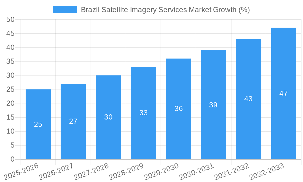
The Brazil satellite imagery services market is experiencing robust growth, driven by increasing government initiatives for infrastructure development, precision agriculture, and environmental monitoring. The market's Compound Annual Growth Rate (CAGR) of 9.62% from 2019 to 2024 indicates a significant upward trajectory. This growth is fueled by the expanding adoption of satellite imagery across diverse sectors, including geospatial data acquisition and mapping for urban planning, natural resource management for sustainable agriculture and deforestation monitoring, and surveillance and security applications for enhancing public safety. The government sector, a major end-user, is investing heavily in advanced technologies for infrastructure projects and national security, further stimulating market expansion. While data limitations prevent precise market sizing, considering the 9.62% CAGR and assuming a 2024 market value around $200 million (an estimate based on global market trends and Brazil's economic size), the market size could reach approximately $260 million by 2025 and continue its expansion through 2033. The market is fragmented, with key players like ESRI, Airbus, Trimble, and Maxar Technologies competing alongside local and regional providers.
However, challenges remain. High initial investment costs for satellite imagery acquisition and analysis can limit accessibility for smaller companies and organizations. Furthermore, data security and privacy concerns, coupled with the need for robust data processing infrastructure, pose significant restraints. The growth, nonetheless, will be largely influenced by successful integration of advanced analytics and AI capabilities to provide more actionable insights from satellite imagery data, alongside the continuous improvements in sensor technology, which will allow for greater image resolution and data acquisition efficiency. The segmentation by application (geospatial, natural resources, etc.) and end-user (government, construction, etc.) offers significant opportunities for targeted market penetration and the development of specialized services tailored to specific industry needs. Brazil's large geographical area, coupled with the country’s increasing focus on technological advancement, presents a substantial and expanding market opportunity for satellite imagery service providers.
Brazil Satellite Imagery Services Market: A Comprehensive Report (2019-2033)
This meticulously researched report provides an in-depth analysis of the Brazil Satellite Imagery Services Market, offering invaluable insights for stakeholders, investors, and industry professionals. Covering the period from 2019 to 2033, with a base year of 2025 and a forecast period of 2025-2033, this report delivers actionable intelligence to navigate the dynamic landscape of this burgeoning market. The market is projected to reach xx Million by 2033, exhibiting a compelling CAGR of xx% during the forecast period.
Brazil Satellite Imagery Services Market Market Dynamics & Concentration
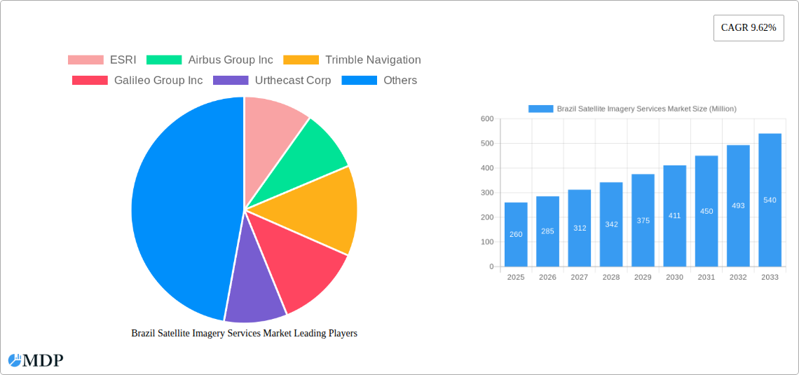
The Brazilian satellite imagery services market is characterized by a moderate level of concentration, with key players like ESRI, Airbus Group Inc, Trimble Navigation, and Maxar Technologies holding significant market share. However, the market is also witnessing increased competition from emerging players and smaller, specialized firms. The market's growth is driven by substantial investments in infrastructure development, a growing need for precise geospatial data across various sectors, and increasing government initiatives promoting the adoption of advanced technologies. Regulatory frameworks, while generally supportive, present some challenges related to data privacy and security. The market also witnesses continuous innovation in sensor technologies, data processing capabilities, and analytical tools. Furthermore, M&A activities are playing a crucial role in shaping the competitive landscape. Over the historical period (2019-2024), approximately xx M&A deals were recorded, with a noticeable increase in the number of deals involving smaller companies being acquired by larger players. Market share distribution among the top five players in 2025 is estimated to be as follows:
- ESRI: xx%
- Airbus Group Inc: xx%
- Trimble Navigation: xx%
- Maxar Technologies: xx%
- Others: xx%
Brazil Satellite Imagery Services Market Industry Trends & Analysis
The Brazilian satellite imagery services market exhibits robust growth, driven by several key trends. The increasing adoption of cloud-based solutions and advanced analytics is transforming the industry. The rising demand for high-resolution imagery across diverse applications, including precision agriculture, urban planning, and environmental monitoring, fuels market expansion. The government's emphasis on infrastructure development projects and national security initiatives further propels market growth. The market is also witnessing a shift toward value-added services, such as data analytics and customized solutions, reflecting evolving customer preferences. Competitive dynamics are intense, with established players and new entrants vying for market share through product innovation, strategic partnerships, and expansion into new geographical regions. The market penetration of satellite imagery services in key sectors like agriculture and infrastructure is gradually increasing, with a projected penetration rate of xx% by 2033. The overall market is estimated to grow at a CAGR of xx% from 2025 to 2033.
Leading Markets & Segments in Brazil Satellite Imagery Services Market
The Brazilian satellite imagery services market demonstrates strong growth across various segments. Geospatial data acquisition and mapping currently holds the largest market share, driven by significant infrastructure development projects and urban expansion. The government sector is the leading end-user, accounting for a substantial portion of the market demand due to its extensive use of satellite imagery for various applications like national security, environmental monitoring, and disaster management. Other key segments experiencing significant growth include:
By Application:
- Natural Resource Management: Driven by the need for efficient resource monitoring and sustainable practices.
- Surveillance and Security: Fueled by government initiatives and the rising demand for enhanced security measures.
- Conservation and Research: Growing focus on biodiversity conservation and environmental studies.
- Disaster Management: Increasingly crucial for effective response and mitigation strategies.
- Intelligence: The demand for actionable intelligence derived from satellite imagery.
By End-User:
- Construction: Utilization of satellite imagery for project planning, site surveying, and monitoring.
- Transportation and Logistics: Optimized route planning, infrastructure monitoring, and asset tracking.
- Military and Defense: Critical for strategic planning, border security, and intelligence gathering.
- Forestry and Agriculture: Precision farming, deforestation monitoring, and resource management.
Key drivers for segment dominance include robust government support for technological advancement and infrastructure projects, along with the increasing awareness of the cost and time-saving benefits provided by satellite imagery. The Amazon region is a significant driver of growth due to the high demand for monitoring deforestation and environmental conservation.
Brazil Satellite Imagery Services Market Product Developments
Recent product developments in the Brazilian satellite imagery services market include improvements in sensor technology, offering higher resolution and broader spectral range imagery. Advancements in data processing and analytics provide more efficient and accurate information extraction. Cloud-based platforms facilitate easy access and collaborative data analysis, while integration with GIS software enhances workflow efficiency and data visualization capabilities. These innovations improve market competitiveness by providing enhanced capabilities, facilitating faster analysis, and improving data accuracy, ultimately leading to a higher return on investment for customers.
Key Drivers of Brazil Satellite Imagery Services Market Growth
The Brazilian satellite imagery services market's robust growth is fueled by several key factors. First, substantial government investment in infrastructure development projects creates a strong demand for precise geospatial data. Second, the increasing adoption of precision agriculture and sustainable resource management drives the need for high-resolution satellite imagery. Third, improvements in sensor technology and data processing capabilities provide more accurate and timely information. Finally, rising concerns regarding national security and environmental monitoring are driving government spending in this sector.
Challenges in the Brazil Satellite Imagery Services Market Market
Challenges faced by the Brazilian satellite imagery services market include high initial investment costs for advanced technologies, potential data security and privacy concerns, and the need for skilled professionals to interpret and analyze satellite imagery data. Furthermore, competitive pressure from both domestic and international players influences market dynamics. Regulatory hurdles related to data acquisition and usage also add complexity to market operations. These factors can influence the overall cost and timely delivery of projects, creating obstacles to market growth.
Emerging Opportunities in Brazil Satellite Imagery Services Market
Significant opportunities exist for growth in the Brazilian satellite imagery services market. The development of advanced analytics tools that can extract actionable insights from satellite imagery offers vast potential for improving efficiency and decision-making across diverse industries. Strategic partnerships between satellite imagery providers and downstream technology companies create synergistic opportunities to integrate data seamlessly into various applications and workflow systems. Expanding the market into underserved regions by providing affordable and accessible services also presents significant potential for growth.
Leading Players in the Brazil Satellite Imagery Services Market Sector
- ESRI
- Airbus Group Inc
- Trimble Navigation
- Galileo Group Inc
- Urthecast Corp
- Satellogic
- L3 Harris corporation
- Digital globe Inc (Maxar Technologies)
Key Milestones in Brazil Satellite Imagery Services Market Industry
- 2020, Q3: Launch of a new high-resolution satellite by Airbus Group Inc.
- 2021, Q1: Partnership between ESRI and a Brazilian agricultural company to provide precision farming solutions.
- 2022, Q4: Government initiative to promote the use of satellite imagery for disaster management.
- 2023, Q2: Acquisition of a smaller Brazilian imagery company by Maxar Technologies.
- 2024, Q1: Successful launch of the first Brazilian Earth Observation satellite. (These milestones are examples, replace with actual data).
Strategic Outlook for Brazil Satellite Imagery Services Market Market
The Brazilian satellite imagery services market is poised for significant growth in the coming years, driven by technological advancements, increasing government support, and the growing demand for geospatial data across diverse sectors. Strategic opportunities exist for companies that can develop innovative solutions that integrate satellite imagery with other data sources, such as IoT sensors and AI-powered analytics. Focusing on providing customized and value-added services will be key to capturing market share and achieving long-term success. The focus on sustainability and environmental monitoring will further bolster market growth.
Brazil Satellite Imagery Services Market Segmentation
-
1. Application
- 1.1. Geospatial Data Acquisition and Mapping
- 1.2. Natural Resource Management
- 1.3. Surveillance and Security
- 1.4. Conservation and Research
- 1.5. Disaster Management
- 1.6. Intelligence
-
2. End-User
- 2.1. Government
- 2.2. Construction
- 2.3. Transportation and Logistics
- 2.4. Military and Defense
- 2.5. Forestry and Agriculture
- 2.6. Other End-Users
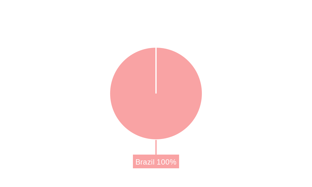
Brazil Satellite Imagery Services Market Segmentation By Geography
- 1. Brazil
Brazil Satellite Imagery Services Market REPORT HIGHLIGHTS
| Aspects | Details |
|---|---|
| Study Period | 2019-2033 |
| Base Year | 2024 |
| Estimated Year | 2025 |
| Forecast Period | 2025-2033 |
| Historical Period | 2019-2024 |
| Growth Rate | CAGR of 9.62% from 2019-2033 |
| Segmentation |
|
Table of Contents
- 1. Introduction
- 1.1. Research Scope
- 1.2. Market Segmentation
- 1.3. Research Methodology
- 1.4. Definitions and Assumptions
- 2. Executive Summary
- 2.1. Introduction
- 3. Market Dynamics
- 3.1. Introduction
- 3.2. Market Drivers
- 3.2.1. Increasing Adoption of Location-based Services; Satellite data usage is increasing
- 3.3. Market Restrains
- 3.3.1. High-resolution Images Offered by Other Imaging Technologies
- 3.4. Market Trends
- 3.4.1. Natural Resource Management is Expected to Significant Share
- 4. Market Factor Analysis
- 4.1. Porters Five Forces
- 4.2. Supply/Value Chain
- 4.3. PESTEL analysis
- 4.4. Market Entropy
- 4.5. Patent/Trademark Analysis
- 5. Brazil Satellite Imagery Services Market Analysis, Insights and Forecast, 2019-2031
- 5.1. Market Analysis, Insights and Forecast - by Application
- 5.1.1. Geospatial Data Acquisition and Mapping
- 5.1.2. Natural Resource Management
- 5.1.3. Surveillance and Security
- 5.1.4. Conservation and Research
- 5.1.5. Disaster Management
- 5.1.6. Intelligence
- 5.2. Market Analysis, Insights and Forecast - by End-User
- 5.2.1. Government
- 5.2.2. Construction
- 5.2.3. Transportation and Logistics
- 5.2.4. Military and Defense
- 5.2.5. Forestry and Agriculture
- 5.2.6. Other End-Users
- 5.3. Market Analysis, Insights and Forecast - by Region
- 5.3.1. Brazil
- 5.1. Market Analysis, Insights and Forecast - by Application
- 6. Competitive Analysis
- 6.1. Market Share Analysis 2024
- 6.2. Company Profiles
- 6.2.1 ESRI
- 6.2.1.1. Overview
- 6.2.1.2. Products
- 6.2.1.3. SWOT Analysis
- 6.2.1.4. Recent Developments
- 6.2.1.5. Financials (Based on Availability)
- 6.2.2 Airbus Group Inc
- 6.2.2.1. Overview
- 6.2.2.2. Products
- 6.2.2.3. SWOT Analysis
- 6.2.2.4. Recent Developments
- 6.2.2.5. Financials (Based on Availability)
- 6.2.3 Trimble Navigation
- 6.2.3.1. Overview
- 6.2.3.2. Products
- 6.2.3.3. SWOT Analysis
- 6.2.3.4. Recent Developments
- 6.2.3.5. Financials (Based on Availability)
- 6.2.4 Galileo Group Inc
- 6.2.4.1. Overview
- 6.2.4.2. Products
- 6.2.4.3. SWOT Analysis
- 6.2.4.4. Recent Developments
- 6.2.4.5. Financials (Based on Availability)
- 6.2.5 Urthecast Corp
- 6.2.5.1. Overview
- 6.2.5.2. Products
- 6.2.5.3. SWOT Analysis
- 6.2.5.4. Recent Developments
- 6.2.5.5. Financials (Based on Availability)
- 6.2.6 Satellogic
- 6.2.6.1. Overview
- 6.2.6.2. Products
- 6.2.6.3. SWOT Analysis
- 6.2.6.4. Recent Developments
- 6.2.6.5. Financials (Based on Availability)
- 6.2.7 L3 Harris corporation
- 6.2.7.1. Overview
- 6.2.7.2. Products
- 6.2.7.3. SWOT Analysis
- 6.2.7.4. Recent Developments
- 6.2.7.5. Financials (Based on Availability)
- 6.2.8 Digital globe Inc (Maxar Technologies)
- 6.2.8.1. Overview
- 6.2.8.2. Products
- 6.2.8.3. SWOT Analysis
- 6.2.8.4. Recent Developments
- 6.2.8.5. Financials (Based on Availability)
- 6.2.1 ESRI
List of Figures
- Figure 1: Brazil Satellite Imagery Services Market Revenue Breakdown (Million, %) by Product 2024 & 2032
- Figure 2: Brazil Satellite Imagery Services Market Share (%) by Company 2024
List of Tables
- Table 1: Brazil Satellite Imagery Services Market Revenue Million Forecast, by Region 2019 & 2032
- Table 2: Brazil Satellite Imagery Services Market Revenue Million Forecast, by Application 2019 & 2032
- Table 3: Brazil Satellite Imagery Services Market Revenue Million Forecast, by End-User 2019 & 2032
- Table 4: Brazil Satellite Imagery Services Market Revenue Million Forecast, by Region 2019 & 2032
- Table 5: Brazil Satellite Imagery Services Market Revenue Million Forecast, by Country 2019 & 2032
- Table 6: Brazil Satellite Imagery Services Market Revenue Million Forecast, by Application 2019 & 2032
- Table 7: Brazil Satellite Imagery Services Market Revenue Million Forecast, by End-User 2019 & 2032
- Table 8: Brazil Satellite Imagery Services Market Revenue Million Forecast, by Country 2019 & 2032
Frequently Asked Questions
1. What is the projected Compound Annual Growth Rate (CAGR) of the Brazil Satellite Imagery Services Market?
The projected CAGR is approximately 9.62%.
2. Which companies are prominent players in the Brazil Satellite Imagery Services Market?
Key companies in the market include ESRI, Airbus Group Inc, Trimble Navigation, Galileo Group Inc, Urthecast Corp, Satellogic, L3 Harris corporation, Digital globe Inc (Maxar Technologies).
3. What are the main segments of the Brazil Satellite Imagery Services Market?
The market segments include Application, End-User.
4. Can you provide details about the market size?
The market size is estimated to be USD XX Million as of 2022.
5. What are some drivers contributing to market growth?
Increasing Adoption of Location-based Services; Satellite data usage is increasing.
6. What are the notable trends driving market growth?
Natural Resource Management is Expected to Significant Share.
7. Are there any restraints impacting market growth?
High-resolution Images Offered by Other Imaging Technologies.
8. Can you provide examples of recent developments in the market?
N/A
9. What pricing options are available for accessing the report?
Pricing options include single-user, multi-user, and enterprise licenses priced at USD 3800, USD 4500, and USD 5800 respectively.
10. Is the market size provided in terms of value or volume?
The market size is provided in terms of value, measured in Million.
11. Are there any specific market keywords associated with the report?
Yes, the market keyword associated with the report is "Brazil Satellite Imagery Services Market," which aids in identifying and referencing the specific market segment covered.
12. How do I determine which pricing option suits my needs best?
The pricing options vary based on user requirements and access needs. Individual users may opt for single-user licenses, while businesses requiring broader access may choose multi-user or enterprise licenses for cost-effective access to the report.
13. Are there any additional resources or data provided in the Brazil Satellite Imagery Services Market report?
While the report offers comprehensive insights, it's advisable to review the specific contents or supplementary materials provided to ascertain if additional resources or data are available.
14. How can I stay updated on further developments or reports in the Brazil Satellite Imagery Services Market?
To stay informed about further developments, trends, and reports in the Brazil Satellite Imagery Services Market, consider subscribing to industry newsletters, following relevant companies and organizations, or regularly checking reputable industry news sources and publications.
Methodology
Step 1 - Identification of Relevant Samples Size from Population Database


Step 2 - Approaches for Defining Global Market Size (Value, Volume* & Price*)

Note*: In applicable scenarios
Step 3 - Data Sources
Primary Research
- Web Analytics
- Survey Reports
- Research Institute
- Latest Research Reports
- Opinion Leaders
Secondary Research
- Annual Reports
- White Paper
- Latest Press Release
- Industry Association
- Paid Database
- Investor Presentations

Step 4 - Data Triangulation
Involves using different sources of information in order to increase the validity of a study
These sources are likely to be stakeholders in a program - participants, other researchers, program staff, other community members, and so on.
Then we put all data in single framework & apply various statistical tools to find out the dynamic on the market.
During the analysis stage, feedback from the stakeholder groups would be compared to determine areas of agreement as well as areas of divergence
